
Disaster preparedness is about having an established safety plan. By the time a severe storm hits, the challenge of staying safe becomes much greater.
In case of emergency, dial 9-1-1.
Safety Steps to Prepare
Before the Storm
- Determine if your home, business, schools or necessary travel routes are in at-risk areas.
- Learn the plan for your local school. Parents of school age children should contact their school district or visit their websites to learn what steps the district will take to ensure student safety. This may include school closures and evacuations.
- Know all your local access roads and understand that some may be blocked by debris or water. Have an alternate route. Stay informed on road and highway conditions by visiting the Riverside County Transportation Department's website at rctlma.org/trans and Caltrans' website at quickmap.dot.ca.gov.
- View a video about driving in snow and winter conditions
- Flood insurance: Most homeowners insurance does not cover floods or flows from natural disasters. Make sure your home is protected. Refer to the National Flood Insurance Program website. Most flood insurance policies take up to 30 days to go into effect.
- Have an emergency plan and a disaster kit ready to go. For more information, click here.
As the Storm Approaches
- Follow all orders by public safety officials
- Sign up for emergency alerts
- Leave before any debris flows begin. Debris flows are fast-moving, deadly landslides. If debris mud or water are already flowing, get higher than the flow, by moving to the highest floor in your home.
- Heed all evacuations. Evacuations warnings will be issued for at-risk areas 24-48 hours before an expected storm. As stated above, the safest time to leave is before any flow begins. Evacuation orders will be issued 6-12 hours before the storm.
- Monitor official weather reports and heed weather alerts. Understand that the weather where you are can be different than back in the mountains where the flows start.
- Never drive or walk into flood waters, mud or debris, and never go around barricades. It is impossible to know how deep the water or mud is just by looking at it, and the depth can change quickly.
- Protect your property structures with sandbags and other methods to divert water from entering structures and reduce erosion on your property. Visit RVCFire.org to see a list of local fire stations offering limited and unfilled sandbags and sand. Read the County's new Flood Guide for Homeowners to learn about protecting your home and property.
Community Evacuation Maps
In some areas public safety officials utilize zones to alert residents of emergencies such as fires and storms, and to conduct evacuations. By knowing your zone you will be able to quickly react in the event of an emergency.
.png)
Temescal/Elsinore Valley Evacuation Zones
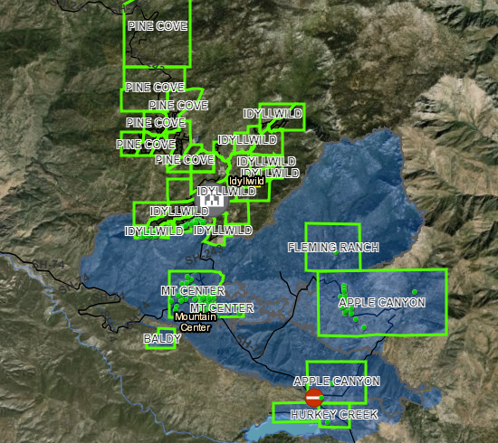
Mountain Communities Evacuation Zones
During evacuation warnings and orders, you should leave immediately and seek shelter outside all evacuation zones.
If you are told to evacuate but you stay, you are risking your life. If you do not evacuate when evacuations are called for you could be isolated and trapped without help for many days, with roads impassible and utilities disrupted or destroyed.
 BLUE areas of the map indicate areas that are at risk for flooding, mud and debris flows. Impacts to these areas may include roads that may become impassible and deadly, as well as disrupted or destroyed utilities.
 YELLOW means a zone is currently under Evacuation Warning: Potential threat to life and/or property. Those who require additional time to evacuate, and those with pets and livestock should leave now.
 RED means a zone is currently under an Evacuation Order: Immediate threat to life. This is a lawful order to leave now. The area is lawfully closed to public access.